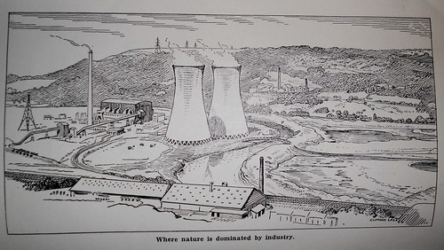
A Tune For All those that betrayed the Vision of Cromwell Bottom LNR
We here a lot of music from Political Lackeys that call themselves Councillors
What is Calderdales Position on renewal of the Third Tier Site as an LNR ?
Why is the Adjacent Landfill Site allegedly remediated enough to run a cafe without planning permission not yet nominated as Part of the LNR ?
Cromwell Bottom

Friday 2 August 2019
Monday 3 September 2018
Stakeholder Consultation Deep Excavation Cromwell Bottom LNR
F.E.ET. Freshwater Environment Ecology Trust

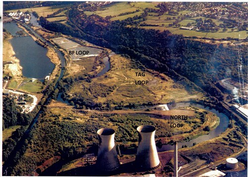
F.E.ET. Freshwater Environment Ecology Trustt Have operated on Cromwell Bottom as a Phase 1 recording Site since circa 2000 and hold a substantial body of records . We are a principle stakeholder on the reserve and are concerned about the plans to excavate a former licenced fly ash site to which CBWG wish to undertake Deep Excavation
The Trust believes and are open to be proven wrong that a preconceived agenda is a foot which is not wholly in the interest of Flora and Fauna of the site and that a substantial level of collusion appears to be occurring to circumvent legitimate and professional concerns
Our view is solely driven on the basis of a full understanding of what Cromwell Bottom Contains and the ultimate protection of flora and fauna on the reserve
In its current form I do not believe Calderdale Council have fully engaged all Groups and a process of exclusion exists because the view is disliked because it runs contrary to amneinty development
CURRENT MANAGEMENT & MONITORRING ISSUES
Serial 01/15


Serial 01/15
Consult 0142
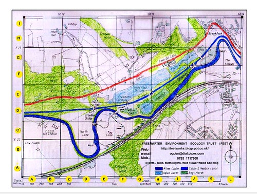
Site Cromwell Bottom LNR
Authority Callderdale Metropolitan
Council
Effective
Stakeholders Active at the Locality
Owners
Calderdale
Metropoloitan Council
Primary
Contact
XXXXXXX Calderdale Council , Lower Valley Countryside Officer
Trustees
( CBWG ) unspecified
Statutory
EA
CRT
Yorkshire
Water
National
Grid
Locally
FEET
– Freshwater environment Ecology Trust
CBWG
– Cromwell Bottom Wildlife Group
Angling Clubs with Fishing Rights
Bradford
No 1
Brighouse Anglers
Avocet
Owners
of Agricultural Land in Proximity
Water Ski Lake
Ward Councillors
Dear
XXXXX
Hope
you are well . Thank you to both you and XXXX for forwarding
detaiI of the project intention to which I write
in respect of Stakeholder Comment. For avoidance of doubt the +
Freshwater Environment Ecology Trust (F.E.ET ) which express a view
independent of the parties reflected contrary overlap of membership
in both CBWG and HSSS
+
Cromwell Bottom LNR is Phase 1 Recording Site to which the FEET have
undertaking records from circa 2000
Background
(i)
I
highlight the lateness of consultation
to a Primary Stakeholder given the projected schedule on your co-joint project
as lead officer
(ii)
The
absence of visible information in respect of Statutory Consultees
as part of your Project Scheme and those other stakeholders that may be implicated
by abstraction ( those with fishing rights) or in close proximity
(iii)
the
absence of an Environmental Impact Assessment should in the event the project
substantially raise and /or lowers water level , if only to develop a
contingency with minimum harm to the ecology in the event of the project
failing
(iv)
The
absence, for avoidance of doubt , or lack of clarity on any boundary
limits of the project
(v)
The
citation of support or input which is not based on (a)
technical assessment on site , (b) is outdated , (c) lacks objective evidential
support for the project (d) in the case of entomological assessment a
limited window of one year or season being an exceptional year .
(e) No indication of quantifiable volumes needed to maintain the water body by
means of abstraction and whether sustainable or not (f) no permeability
estimates on the loss of subterranean water into aquifers or
passage through existing sub strata (g) Based on the creation of islets and the
CEG estimate of 30 cm top soil coverage it would likely mean more fly ash would
be excavated than can be reasonable disposed of and is likely to be wind
dispersed in hot dry seasons with potential respiratory implications based on
particle size (h) work undertaken by the HSS fails to take into
consideration the potential overall impact as discussed below and FEET have
received no copy of any Botanical or NVC Survey undertaken by any professional
(vi)
It
is noted that one of the principle justifications for the project is aesthetics
I
understand that you the Council, would seek to promote this project outside
planning consideration and I understand from previous dialogue that you are of
the belief that the Environment Agency have no objection to it and you have
indicated there are no flood control issues that the agency are concerned about
I
also made you aware of the Trusts Concerns as lead
officer in the overall disregard to the councils own policies and
statutory obligations some of which previously misled the agency (EA) – below
-and the general principles of consultation to date on CB LNR .
(i)
The
draining of Leachate from the North Loop into the Calder which miraculously
disappeared on the Day of the Agency Site Visit
(ii)
The
planning application to which you as principle are aware is
not extant for a Café on a Landfill Site and to which I believe the Agency were
misled given its current use as such and promoted reference to it
as a visitor centre or cafe
Therefore
, Robin , I feel it necessary , to make clear and detailed record of concerns
In
matter at hand , Without going into substantive detail they are some
grounds for clarification briefly raised
Firstly
(1A) Lagoon
1 is 20 m from a major river is located in
Flood Zone 3 and is designated as a Flood Holding area, which requires a Flood
Risk Assessment, given the nature of work is excavation and / or in the
interest of safety , that being the reserves current designated use as Public
Open Space , It is likely in association with 1b increasing water displacement
at this locality would contravene the Direction of Flood Control within the
Local Authority. In effect if the area becomes a substantive water body ,
(unqualified ) the primary use of the land holding is impacted upon as a Flood
Holding area for the reasons highlighted below. Whilst these gravel pits
have been historically filled with PFA waste, I believe under licence
, the term Lagoons have been historically and inaccurately
used , and in the current form relates to the seasonal accumulation of
surface water on the PFA. The Flood Storage Area located between Canal
and River is a first line surge defence toward Brighouse before the low lying
pasture at Lilands . Whilst the Flood Storage area is limited by the valley
contour there remains significant infrastructure buildings and factory’s
within its scope and contour level , that to include the
infrastructure pathways embankments and NG infrastructure in proximity
Firstly
(1B) Displacement
- the promotion of large volumes of water on a flood plain catchment area
would result in displacement of water further down the valley at peak flows
( The large number of KTonne Displacement already
presented by the filling of the oxbows on the CB Landfiill Loops and the
run off from the Low Fields Loops coupled with the Substantive rapid run off
from Peat Uplands and adjacent Steep Southern Slopes locally opposite
on the Calder are self evident . The last Displacement study
on the Flood plain as I understand it is some years old and
certainly has increased since then )
Secondly in respect of
raising water levels it is assumed that an abstraction licence would be one
means of doing so and would be granted and it would be likely that the water
would be removed from the River and / or Canal at low flow times during summer
when water would be at a premium and important to fish populations , . I
believe the Trust has made the Councils Biodiversity Officer aware
of invasive on site Crassula and it remains unclear what initiative
the Local Authority is undertaken to limit it , given the runoff culverts back
into the Calder and close proximity to The Calder & Hebble Navigation . Due
regard should be applied to the Type or Terms of abstraction
licence Water Resources Act 1991 (WRA 1991 and in
respect to any practical implication of the of licence type granted , if
granted in terms of simply filling the structure
I
acknowledge your view to limiting spread of Pygmy weed and caution on any
contradiction in respect of creating any additional run out in respect of its
spread given the mention of irrigating the Eastern and Western Woodlands
Thirdly , in balance the
natural ecological succession has given rise to more productive biodiversity
than what the impact or ingress to Willow Wetland and wet woodland
would yield based on any impact on the component mosaic
known as Lagoon 2 . In the management of this reserve and its uniqueness is
dependent on retained Habitat Mosaics . The evidence based geophysical
benefit of wet woodland at this site has been given separate in 8b below
It
would appear that we are not in variance with the value of both woodlands East
and West assuming the project is kept within clearly defined bounds and that
the value of Lagoon 1 as one of the component matrix is noted as having value ,
if not perhaps overstated. It is unlikely or unclear that PH and DO levels from
a static Rain filled water body would support Fish
populations. The Ornithological Value of the Reed Bed in terms of species
diversity should be graded on the Number of RDB Scarce or BAP Promoted species
to which again there is no guarantee that any given species is likely to
established or for that matter is established . There is also no
guarantee in the quality of water abstracted from the Calder or Canal in terms
of industrial discharges or any breeches , to which abstraction
would possibly accumulate on site
Fourthly it is not
the intention present a full Hydological assessment at this
time but it is necessary to consider factors relevant to an
EIA The site Lagoon 1 is located parallel
to a river gradient on terrain with an aquifer What is keeping water in
the lagoon at the moment is PFA. If layers of PFA are removed it is
likely any water displaced into it will in any case permeate
substrata and have a tendency to drop to the level of the
River bed still permeating at the same or enhanced rate .It
is unclear to what area and extent is meant by deep excavation, In
the event of attempting a deep excavation ( unqualified ? ) what
may likely happen is that water levels in the gravel pit would
likely drop to the level of the river causing collapse of soil structure
and embankments or drop to the level of any adjusted displacement and
altered permeability to the aquifer again no one can be
precise in regard to any model , but the net result would be to effectively
promote the draining of the lagoon which historically JBL report the habitat to
be shallow marsh NVC Type prior to any intervention.
There
is no guarantee or evidence that the projected intervention would
technically raise and hold water levels on this site if it proceded. Trustess (
CBWLG ) therefore should with due diligence consider the spending of monies in
respect of cost benefit and whether or not more practical achievable works on
the reserve could be undertaken
Fifthly .The Trust assert with due
diligence in terms of excavating PFA due regard should be given to any
Heavy Metal Toxicity or other Compounds likely to impact within the environment
which accompanies the burning of coal and the subsequent disposal of fly ash,
particularly in respect to the proximity of the water Course and any fish or
amphibia populations I am not sure that any one has assessment in
respect of this chemistry and I have seen no objective advice discussion or
evidence on PFA management from Prof Vann since he has been cited in the
project outline document.. The PFA has been largely contained beneath a top
layer which at the time of its dispersal ranged between 1 – 11/2 ft and has
likely increased in depth over the 30 year period of revegatation and has been
subject to a long time period of dilute and disperse and is unlikely to
have adverse effect , but it is no ones legacy to assume . In terms of
the chemistry of Fly Ash findings are likely reflective of the coal type burnt
at the CEG facility at that time , which I am certain no one has gave
consideration to in any implied EIA and records long since lost or unkept
. On the basis of common sense the overall colour of Fly Ash across the site is
pale Grey indicating a low Carbon burn
Sixthly , I would ask full
council to be aware of the obligations under flood plain control and any
extant policy UDP , Legal or Otherwise in the light of devasting floods
in Calderdale recently and I would be minded to guide Council on
legislation relating Water Framework Directive 2000 and to
Owners of Riparian Land and , were recent legal
Precedent has resulted in adjacent property owners claiming damages from any
acts of Riparian Land Owner Activity Upstream. I am minded to comment on the
increased consequences of displacement which the addition of
water bodies planned existing or otherwise would create cummulately ( I
draw to your attention the Water Ski Lake , Ashgrove basin development etc. I
also minded to advise Trustees of CBWG that vicariously there could potentially
be a shared liability which would have implications on each named Trustee ( I
would advise to seek their own legal advice on liability)
In
matters of practical law it is unclear if the Council own Title to the River
and there are complex legal concerns to those with extant fishing rights whom
in the event of abstraction should be fully consulted
Seven
The
crude bunds to the West and East of the existing standing water known as Lagoon
1 are simple crude embankments never stucturallyl intended to separate or
contain large bodies of water . There is clear concern in regard to any
breach due any additional hydrostatic pressure brought about by deepening
and introducing of further water . Such bunds were placed solely to separate
the amorphous PFA and would not be structurally sound . Point 4 is
reiterated that any alteration in water level resulting in soil or Bund
collapse particularly by erosion on the Southern Boundary adjacent to the
Calder would transgress back toward the river giving rise to a potential bank
issue or breach to the course of the Calder . In conclusion the extent of
of Earth Movement , required stabilising to make safe any parties to boundaries
described given the reserve to be open space would have to be substantial and
bordering on a major engineering project and in the absence of it could
potentially end up as a cluster
Eight
As
noted in your communication the Biodiversity Value of Wet Woodland and Woodland
which seasonally floods is acknowledged - FEET would seek to have
this ecological succession preserved for a number of sound reasons (not
for publication) . The Trust would therefore seek to clearly qualify the
operational area of the project and whether there is any intention to enlarge
or expand the area of Lagoon1 which would ingress into these habitats East and
West
The
Woodland to the East of this demarcation contains Nationally Scarce Plants .
such as Round Leaved Wintergreen and Twayblade and a bund collapse could
potentially impact on their presence
It
is also unclear in respect of the Cost and Source of the Funding required
to undertake this work which you imply deep excavation on Council Land Managed
as POS Public Open Space. It is also unclear if the Councils policy on
tendering for this work has been adhered to given the collaborative nature of
the project. It is also unclear from your submission what caveats relate to the
original Permit or Licence associated with the site .The document
provided does not indicate the intended area of work, with specific reference
to Clearance of any Ecological Sucession , ie to what boundaries are you
applying this project too ? with particular clarity on any potential
transgression on the Western Side Lagoon
Nine
I
have now been made aware of the Entomological Report as of 22 August 2018
, and to which has not been widely circulated to all stake
Holder Groups .
Such
a report was commissioned by the Authority . It is unclear precisely what the
brief was for the report, and such a report points out that the
management of habitat is the responsibility of the Client. Nevertheless , it
does appear to be bias led to a particular client brief. In the assessment of
Brookfoot we ourselves have had difficulty revisiting and locating original
stands of Bryophyte in the Spagnum Area as a result of the very considerable
surface disruption in the flood year.
It is therefore important that any project implications are guided by full
consultation by the many potential stakeholders that would be impacted upon
I
therefore critique these finding .
RW
Report May – August 2017
CB
undergoes substantial seasonal variance in water levels with levels also
at further variance within the specific habitat Mosaics. Early Sping levels
give rise to ground conditions and shallow water temperatures crucial for
Invertebrates such as Amphibia and the generation of early spring diptera
– syrrphiddae and hymenoptera such as Solitary Wasps which are often
vital food for the wider small bird populations at critical breeding
times and important pollinators in the overall ecological chain ( EG Returning
Migratory species such as Willow Warbler. The large variation in diurnal and
annual temperature ranges experiences on the shallow sub layers of PFA
means the reserve is inherently prone to conditions were ground moisture is
substantially or rapidly lost. ( Hannah PH DO and Conductivity Meter
Monitoring ) The importance of relatively high humidity retained under
the tree canopy at lower vegetative or ground layers ensures invertebrate
breeding populations are maintained . The importance of transitional woodland
therefore can not be over emphasised for any number of reasons . I would also
assert and alert that the conventional methods of NVC habitat management do not
necessarily readily lend to the very fragile and unconventional sub soils or infils
It
is noted that prior to intervention by CBWG around the boundary area of Pixie
Wood removal of patchy tree canopy substantially dried off much of the
peripheral wet areas contributing to some of the rarer Bryophytes
recorded and found in the that location . Further implications are discussed
below ( Lessons Learned)
In
the main the report relies upon historical data reporting and Biodiversity
Records Historically , some of which began before any man made interventions.
And indeed as indicated by MD himself when the site was very much in its
natural state as a river valley FEET has a substantial licenced data base
of Taxa over a 19 year longitudinal study on this Phase 1 recording site
including a follow up study on how many of MD original Coleoptera records
have persisted on the site currently. It appears FEET as a Stakeholder
Organisation has been substantially overlooked . Whilst the report makes a
valuable addition to the total number of taxa over time and in particular
species that require detailed study or methodology ( Gen Det , or other
differential interventions in identification) It is only valid for a specific
window in time July – August 2017 and for a limited part of the reserve
without due regard to linkages and Biological Corridors many of which
have been identified by FEET records ,studies and observations
(Eg Translocation Studies on Wing Marked Meadow Brown Maniola
jurtina ) . From our records Aglaesto alni has been present for
some time at CB LNR in number throughout
Original
reporting By FEET in respect of Nationally Scarce species of wet or
decaying woodland were made clear to the local authority whose management
interventions to clear , remove and stack decaying wood from associated and
valuable ecological habit . RW report reflects the overall principle that
within the habitat Mosaics there is substantial biodiversity that remains to be
recorded or in the alternative is difficult to record due to the expertise
required in keying differential identifications. The report for its reasons
given has not addressed the full range of species associated with decaying wood
of woodland margins EG Craneflies nor for that matter the extensive list of
Caddis on across and around the reserve
It
is noted that the Ecological Report even in the absence of ALL records
accords substantial weight to the importance of the Unique Invertebrate
Asssemblages associated with the current NVC Mosaics and indeed our
Mapmate output shows clear figures for total numbers of Taxa on each mosaic
type RW work reflects post completion monitoring in regard to the impact
of the work on the Invertebrate Assemblages and by implication does not
guarantee that the project will in fact protect or strengthen the
importance of invertebrates on site . ( Particularly relevant are
Lepidoptera associated currently with the existing sub surface reed bed -
Wainscotts etc ). That coupled with our own view to the Hydrology , Aquifer
Contour and Gradient in respect of whether water can be held , aside from other
issues such as sustained Water Levels ,Flow, Ph Changes in Standing Water
, and the Quality of Water Abstracted and any issue of introducing contaminants
into standing water etc lead us to be concerned . RW report is based
on assertion without evidence that rewetting the woodlands or
filling an excavated pit is possible
The options for CB LNR to be managed
in terms of component mosaics are manifest but should in accordance to its LNR
status have due regard for species richness balanced with overall impact on
uncommon , Scarce Nationally Scarce or other RDB species . FEET has raised
the profile and benefit of the sucession habitat before with the
Councils Biodiversity Officer FEET historically pointed out to the
Local Authority the importance of various linkage corridors or interventions
that would promote movement of biodiversity around the reserve . In RW work
limitations are made clear in respect of looking at this one section or
part mosaic and its wider interpretation
In
the study management of CB unique Habitat Mosaics the
precept that the NVC Types are typically managed or conform to
conventional measures often overlooks the fragility of the substantive man made
interventions sub soils excavations infills and land fills present on the
site do not necessarily conform to convention
Whilst RW work is a well presented and carefully balanced piece of work which
contributes to the Biological Records on Site it is driven by hypothetical
considerations centred around its limitations which could potentially be
misinterpreted Taken in context with the Councils
view to managing the reserve as a Countryside Park precipitates a number of
conflict of interests. In the assessment of Brookfoot we ourselves have had difficulty
rebisitting and locating original stands of Bryophyte in the Spagnum Area as a
result of the very considerable surface disruption in the flood year
Lessons
Learned
1. In respect of
studies undertaken 2 weeks post flood event in the Spagnum and Area
Abridging Pixie wood it can seen that the fluid dynanics of the River caused a
significant Back wash as flood waters approached Brookfoot . In that study it
was clear that amorphous water channels created in the PFA directed water
back upstream uprooting trees and lying them contra to the flow the river . It
was evident at the boundary of Pixie wood were willow and other trees had been
removed that the lack of tree roots which otherwise contributed to the breaking
and flow dispersal are important agents at play in the flood wash plane
which will play an active role in allaying and dispersing any flood torrent
prior reaching Lilands or Brighouse. The GeoPhysical benefit of Wet woodland
and Woodland West and East aside to Ecological value is not fully appreciated
F
Fly Ash on Spagnum Bog Post Flood 2015

I In respect of
Crassula recording as reported by FEET is present at a number of
locations one in close proxity to the small bridge on the Eastern
Bund . It was evident at the time of monitoring this species that an “
Islet “ management reed cut strategy might be more effective than a “channel
“approach for the following reason
(a)
The
linear spread and progression of Crassula appears to be somewhat slowed or
reduced by any circular reed cut foot print resulting in some degree of
containment and localisation – not a n exact science
(b)
Circular
pools clearances break the line of sight of any dogs inclined to chase water
fowl and creates localised niches
Conclusion
At
this juncture XXXXX, it is difficult to make an informed opinion as to whether
we would object wholly to this project , in the absence of facts
and without the input and views of the Statutory Undertakers ,In the main , for
the reasons discussed , we would not object to the general maintenance of
work on the “ Reedbed “ in its current form but would need assurance that
the Wet Woodlands to the East and West would not be impacted on , particularly
by any structural or breech of alteration of the very crude earth embankments
in situ which were not intended for the purpose of holding water that you would
seek to introduce. I also sincerely take the view , given no technical insight
or guarantee that the project could potentially raise water levels effectively
, that our assessment Consultation should go some way in informing
Trustees CBWLG , as to whether monies spent , in this project would
achieve a cost effective outcome
In
the presentation of this view the Trust at all times place paramount the
welfare and well of flora and fauna and the integrity of the ecosystem is the
Trusts primary concern not a desire or bias in the ecological chain for
aesthetics or other human intervention
That
Said would support the current management of Lagoon 1 in its present
form but for the reasons set ot would oppose any deep excavations or
alteration for the reasons presented herein
I
am sorry that this view or approach may not please all but as I am sure
you appreciate as chair of an organisation that would endorse any impact
or consequence of Freshwater , I must operate with enhanced diligence and as
always an independent view that represents the Calder and Biodiversity
associated with it and CB LNR. Whilst FEET share the commitment and
enthusiasm of CBWG in making it a better place and as accorded by our own
Trust , a profound desire to see improvement , CBWG have on a number of
occasions deviated from their articles of association , principly the extension
of reserve by registering North Loop as a Local Nature Reserve with Natural
England and appear to have adopted a process of not engageing
of other stakeholders contrary to the direction of their Current
Articles. ( Although I note and Thank XXXXXX in regard to her
communication on behalf of that working group ) I can find no reason as to why
the Council would not register North Loop as a Nature Reserve with a view to
managing it as such .
Whilst
not at this stage in full position of all the facts , including that of the EA
Environment Agencies Appraisal I think it necessary to ensure a full
consultation is met . I am unclear to whom the Council have been speaking to
within the various agencies or whether the project only been looked at solely
from the perspective of sustainable places alone
I remain
Cromwell Bottom
Monday 28 May 2018
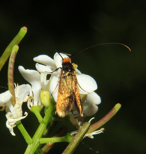
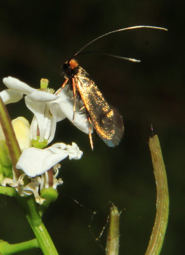
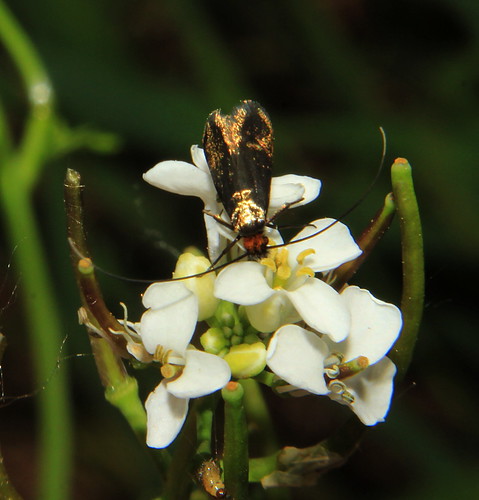
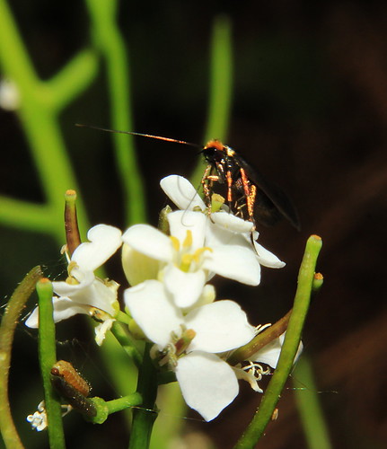
Cromwell Bottom LNR - 0152 Cauchas rufimitrella ABH 7.010
Sun 27th May 2018
This small micro a Longhorn with rufous head was found nectarring on Garlic Mustard by the Calder . The larvae feed within the seed pods .
It shouldnt be confused with the smaller Micropterix calthella ( also with a red head but shorter antennae ) usually found on buttercup which has mouth parts capable of taking pollen
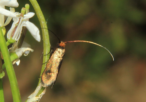
Saturday 8 April 2017
Spring Sitings April 2017
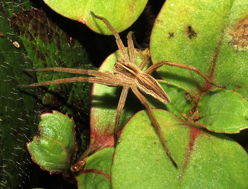
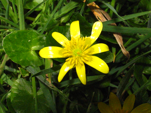
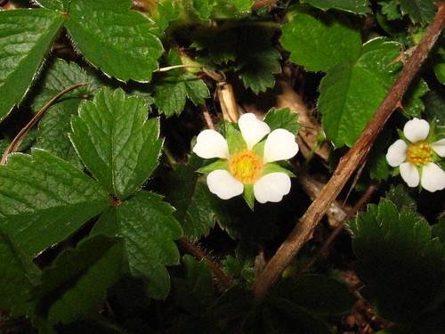
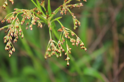
Common About
Nursery Web Spider
Lesser Celandine Ficaria verna
Barren Strawberry
Greater Woodrush Luzula sylvatica
Nursery Web Spider
Lesser Celandine Ficaria verna
Barren Strawberry
Greater Woodrush Luzula sylvatica
Subscribe to:
Posts
(
Atom
)